Well, no one really knows. Polheim means “house of the pole” in Norwegian, and is the name that the Amundsen party gave the tent they set up at the South Pole when they arrived on Dec 14, 1911. It was a spare tent that they had carried all the way from the coast, and because they no longer needed it for the trip back, they left it standing at the Pole. Inside the tent they left items that they also did not need for the trip back, including two sextants and some clothes. When Scott arrived at the Pole a month later he found the tent still standing.

Polheim on Dec 14, 1911. From left, Amundsen, Hanssen, Hassel, and Wisting. Photo by Olav Bjaalland.
Scott was the last person to see the tent. The next people to set foot at the South Pole were members of the US Navy when they came to establish the first South Pole Station in 1956. At that time the tent would have been buried under several feet of ice, due to the constant accumulation of snow grains that fall from the sky and never melt. Today the tent is estimated to be under 65 ft (20 mt) of ice. Supposedly, the tent was located at the exact South Pole, but because the navigational instruments used by Amundsen only had an accuracy of about 2 km, there is quite a bit of uncertainty as to the exact location of Polheim. In addition, the plateau moves over time, so the tent would have moved approximately 1 km in the 100 years that have passed since it was erected. Researchers, using handwritten notes from Amundsen, and studying the instruments that he used, have estimated the current location. There are two such estimates. They differ from each other by 700 meters. The first one puts Polheim at 2 km from the current location of the South Pole; the second at 2.7 km.
A few days ago Robert, one of our astronomers, invited me on a pilgrimage to these sites. Robert had studied the literature, drawn maps, and programmed a GPS to take us there. Our destination lied within the boundaries of the clean air sector, an area that is off limits even to us researchers because it is located upwind of very sensitive instruments that continuously monitor the air quality of our planet. The instruments are so sensitive that they can detect the presence of a single person breathing one mile away. So, we had to wait for the winds to shift to a grid East direction, so that our travel would be downwind of the instruments and, with proper permission from NOAA, after dinner on October 11, we were allowed to enter the area.

Skiing in the clean air sector towards Polheim . The surface, sculpted by the wind into small sastrugi, is very hard. Skis hardly make an indentation as they glide over the bumps. The temperature was a chilly -60 C (-76 F), which is several degrees colder than the mean temperature for this time of year, but winds were moderate at under 10 knots, which made for a pleasant trip (Photo by Robert).

Robert checking the GPS coordinates. Yes, we are at the correct location: this is where the first of the two estimates puts Polheim, 20 mt under where Robert is standing. Note how Robert uses a 100-year old technique of tying his bear paw mittens to a rope and hanging them around his neck, so that he can easily take them on and off without losing them, when he needs to use his hands.

Robert took this photo of me at the first estimated Polheim location. We never remove our dark goggles, not even for a photo. Although the sun is only 7 degrees above the horizon, the UV radiation is intense under the ozone hole. Our friends Johan and Christy from NOAA have been monitoring the ozone hole here at the Pole all year long by launching balloons that reach into the stratosphere, up to around 100,000 ft (30 km) of height. They have increased the frequency of their measurements now that the hole is forming. At the beginning of October, the total integrated column of ozone reaches a minimum, at around one third the normal values. After the middle of October the ozone hole starts to fill in again. This year we actually reached the minimum on October 9.
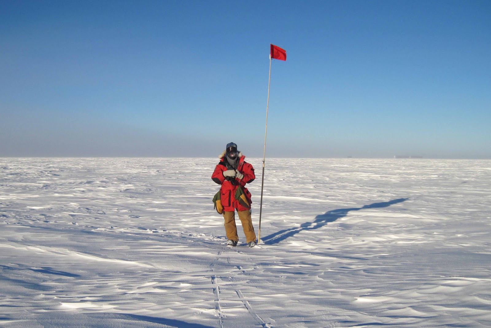
At the second estimated Polheim location we found a flag, which was put in place by one of last year's winterovers with an interest in the history of Polheim. We found the flag in very good conditions. Here Robert is savoring the moment. Could he be standing just 20 mt above Polheim? Nobody knows.

This is the view from Polheim into the clean air sector, not at all different from what Amundsen first and then Scott must have seen 100 years ago. A thin fog was appearing and disappearing on the horizon, but never obscured the dark blue skies above us. It was a wonderful 2-hr trip on the ice, full of emotions, as we walked in the steps of the great polar explorers that our station is named after.
Great that you got the chance to explore the area! I've got a map plotted with both locations from Tim, who also has an abiding interest in the location. Last summer, when we had all the ground-penetrating radar out to survey Old Pole, I tried to convince them to make a run out to Clean Air for a look when the winds shifted. No dice. Perhaps it just isn't meant to be.
ReplyDeletePlease let me know when you make it off the ice and back to Palo Alto - look forward to seeing you again!
-pablo
아이비 - thtopbet.com leovegas leovegas gioco digitale gioco digitale matchpoint matchpoint 276What is the Best Sports Gambling Websites in 2021?
ReplyDelete